This article needs additional citations for verification. (November 2024) |
Dimitsana
Δημητσάνα | |
|---|---|
 | |
| Coordinates: 37°36′N 22°3′E / 37.600°N 22.050°E | |
| Country | Greece |
| Administrative region | Peloponnese |
| Regional unit | Arcadia |
| Municipality | Gortynia |
| Area | |
| • Municipal unit | 110.8 km2 (42.8 sq mi) |
| Elevation | 945 m (3,100 ft) |
| Population (2021)[1] | |
| • Municipal unit | 708 |
| • Municipal unit density | 6.4/km2 (17/sq mi) |
| • Community | 424 |
| Time zone | UTC+2 (EET) |
| • Summer (DST) | UTC+3 (EEST) |
| Postal code | 220 07 |
| Area code(s) | 27950 |
| Vehicle registration | TP |
| Website | www |
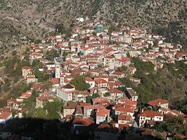
Dimitsana (Greek: Δημητσάνα) is a mountain village and a former municipality in Arcadia, Peloponnese, Greece. Since the 2011 local government reform it has been part of the municipality Gortynia, of which it is the seat and a municipal unit.[2] The municipal unit has an area of 110.759 km2.[3] Dimitsana is built on the ruins of the ancient town Teuthis. It has been registered as a traditional settlement.
Dimitsana is built on a mountain slope at an elevation of 950 meters. From its southern side a marvelous view of the Megalopolis plain and Taygetus is provided. Dimitsana is located 53 km east of Pyrgos, 31 km northwest of Tripoli, 23 km northwest of Megalopoli and 17 km northeast of Andritsaina. The village has a school, a historical library, several churches, a post office, an open-air water-power museum,[4] an open amphitheater, hotels and a square.
- ^ "Αποτελέσματα Απογραφής Πληθυσμού - Κατοικιών 2021, Μόνιμος Πληθυσμός κατά οικισμό" [Results of the 2021 Population - Housing Census, Permanent population by settlement] (in Greek). Hellenic Statistical Authority. 29 March 2024.
- ^ "ΦΕΚ B 1292/2010, Kallikratis reform municipalities" (in Greek). Government Gazette.
- ^ "Population & housing census 2001 (incl. area and average elevation)" (PDF) (in Greek). National Statistical Service of Greece. Archived (PDF) from the original on 2015-09-21.
- ^ Piraeus Bank Group Cultural Foundation[permanent dead link] description of the museum

