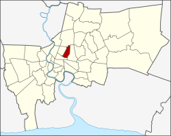
Din Daeng
ดินแดง | |
|---|---|
 Rot Fai Night Market (Ratchada branch) | |
 District location in Bangkok | |
| Coordinates: 13°46′11″N 100°33′10″E / 13.76972°N 100.55278°E | |
| Country | Thailand |
| Province | Bangkok |
| Seat | Din Daeng |
| Khwaeng | 2 |
| Khet established | 14 January 1994 |
| Area | |
| • Total | 8.354 km2 (3.225 sq mi) |
| Population (2017) | |
| • Total | 122,563[1] |
| • Density | 14,590.83/km2 (37,790.1/sq mi) |
| Time zone | UTC+7 (ICT) |
| Postal code | 10400 |
| Geocode | 1026 |
Din Daeng (Thai: ดินแดง, pronounced [dīn dɛ̄ːŋ]) is one of the 50 districts (khet) of Bangkok, Thailand. Its neighbours, clockwise from north, are Chatuchak, Huai Khwang, Ratchathewi, and Phaya Thai.
- ^ "Population and House Report for Year 2017 (see page 2 for data of this district)". Department of Provincial Administration, Ministry of Internal Affairs. Retrieved 1 April 2018. (Search page)