This article needs additional citations for verification. (November 2014) |
Dinajpur
দিনাজপুর | |
|---|---|
City and Municipality | |
|
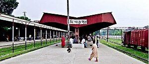
From top (clockwise): Hajee Mohammad Danesh Science & Technology University and Dinajpur Railway Station | |
| Coordinates: 25°37′44″N 88°38′13″E / 25.629°N 88.637°E | |
| Country | |
| Division | Rangpur |
| District | Dinajpur |
| Upazila | Dinajpur Sadar |
| Government | |
| • Type | Mayor–Council |
| • Body | Dinajpur Municipality |
| • Paura Mayor | Syed Jahangir Alam[1] |
| Area | |
| • Total | 22.8 km2 (8.8 sq mi) |
| Population | |
| • Total | 212,275 |
| • Density | 9,300/km2 (24,000/sq mi) |
| • Ethnicities | Bengali |
| Time zone | UTC+6 (Bangladesh Time) |
| National Dialing Code | +880 |
| Website | www |
Dinajpur (Bengali: দিনাজপুর [dinad͡ʒpur]) is a city and the district headquarters of Dinajpur district situated in Rangpur Division, Bangladesh. It was founded in 1786. It is located 413 km north-west of Dhaka in Bangladesh. It is bounded on the north by Suihari, Katapara, Bangi Bechapara, Pulhat, and Koshba on the south; on the east by Sheikhupura; and by the river Punarbhaba on the west.
- ^ "Mayor Dinajpur city's civic body-Dinajpur Municipality". Retrieved 12 September 2019.
- ^ Cite error: The named reference
2022censuswas invoked but never defined (see the help page).


