Dock Bridge | |
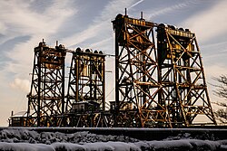
 Amtrak Dock Vertical Lift bridge. | |
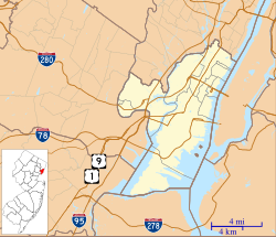
| Location | Passaic River Newark - Harrison New Jersey |
|---|---|
| Coordinates | 40°44′9″N 74°9′43″W / 40.73583°N 74.16194°W |
| Area | 1 acre (0.40 ha) |
| Built | 1935 |
| Architect | Waddell & Hardesty; Waddell, Dr.J.A.L. |
| Architectural style | Through-Truss Lift Bridge |
| NRHP reference No. | 80002484[1] |
| NJRHP No. | 1227[2] |
| Significant dates | |
| Added to NRHP | October 3, 1980 |
| Designated NJRHP | July 21, 1979 |
Dock Bridge | |
|---|---|
| Coordinates | 40°44′09″N 74°09′43″W / 40.7358°N 74.1619°W |
| Carries | Amtrak, NJ Transit (West span) and PATH and Amtrak/NJ Transit (East span) |
| Crosses | Passaic River |
| Characteristics | |
| Design | pair of through-truss vertical lift bridges |
| Clearance below | 24 ft (7.32 m) (closed) 135 ft (41.15 m) (open) |
| Rail characteristics | |
| No. of tracks | 3 (West span), 3 (East span) |
| Track gauge | 4 ft 8+1⁄2 in (1,435 mm) standard gauge |
| Structure gauge | AAR |
| Location | |
 | |
Dock Bridge is a pair of vertical lift bridges crossing the Passaic River at Newark, Essex County and Harrison, Hudson County, New Jersey, United States, used exclusively for railroad traffic. It is the seventh crossing from the river's mouth at Newark Bay and is 5.0 miles (8.0 km) upstream from it.[3] Also known as the Amtrak Dock Vertical Lift, it carries Amtrak, NJ Transit, and PATH trains. It is listed on the state and federal registers of historic places.
- ^ "National Register Information System". National Register of Historic Places. National Park Service. March 13, 2009.
- ^ "New Jersey and National Registers of Historic Places - Essex County" (PDF). New Jersey Department of Environmental Protection - Historic Preservation Office. September 6, 2011. p. 12. Archived from the original (PDF) on August 9, 2017.
- ^ "Lower Passaic River Restoration Project Commercial Navigation Analysis" (PDF). United States Army Corps of Engineers. July 2, 2010. Retrieved March 19, 2012.


