This article has multiple issues. Please help improve it or discuss these issues on the talk page. (Learn how and when to remove these messages)
|
Dom Pedrito | |
|---|---|
| Municipality of Dom Pedrito | |
 | |
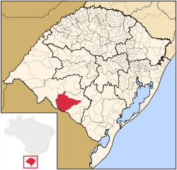
 Location within Rio Grande do Sul | |
| Coordinates: 30°58′01″S 54°40′01″W / 30.967°S 54.667°W | |
| Country | |
| State | |
| Founded | October 30, 1872 |
| Government | |
| • Mayor | Mario Augusto de Freire Gonçalves (PP) (2017-2020) |
| Area | |
| • Total | 5,192.105 km2 (2,004.683 sq mi) |
| Population (2020)[1] | |
| • Total | 38,339 |
| • Density | 7.4/km2 (19/sq mi) |
| Time zone | UTC−3 (BRT) |
Dom Pedrito is a municipality in the state of Rio Grande do Sul, Brazil. It is located at: 30° 58' 58" S 54° 40' 22" W
Nearby cities are: Rosário do Sul, São Gabriel, Lavras do Sul, Bagé, Santana do Livramento and República Oriental do Uruguai. Distance to the capital: 441 km (274 mi)


