| Dommel | |
|---|---|
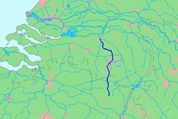
 Location map of the Dommel. | |
 | |
| Location | |
| Countries | Belgium, Netherlands |
| Physical characteristics | |
| Source | |
| • location | Campine |
| Mouth | |
• location | Dieze |
• coordinates | 51°41′42″N 5°18′3″E / 51.69500°N 5.30083°E |
| Length | 120 km (75 mi) |
| Basin features | |
| Progression | Dieze→ Meuse→ North Sea |
The Dommel is a small river in Belgium and the Netherlands, left tributary of the Dieze. It is 120 km long, of which 85 km are in the Netherlands.[1] The Dommel takes in water from the Keersop, Tongelreep, Run, Gender and Kleine Dommel streams and merges at 's-Hertogenbosch with the Aa stream to form the river Dieze, which subsequently flows towards the Meuse. The main cities and towns along the Dommel's course are Peer, Neerpelt, Valkenswaard, Dommelen, Eindhoven, Son en Breugel, Sint-Oedenrode, Boxtel, Sint-Michielsgestel and 's-Hertogenbosch.
- ^ "Waterschap De Dommel". Archived from the original on 2019-03-20. Retrieved 2018-01-24.