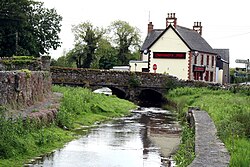
Donaghmore
An Domhnach Mór | |
|---|---|
Village | |
 Donaghmore on the River Erkina | |
| Coordinates: 52°52′21″N 7°36′00″W / 52.87250°N 7.60000°W | |
| Country | Ireland |
| Province | Leinster |
| County | County Laois |
| Area | |
| • Total | 1.44 km2 (0.56 sq mi) |
| Elevation | 1 m (3 ft) |
| Time zone | UTC+0 (WET) |
| • Summer (DST) | UTC-1 (IST (WEST)) |
Donaghmore (Irish: An Domhnach Mór, meaning 'big church')[2] is a small village in County Laois, Ireland. It is in a townland and civil parish of the same name.[2]
It is located in the south of the county near Rathdowney on the main R435 regional road, on the River Erkina, a tributary of the Nore.
- ^ "Donaghmore Map, Laois, Ireland".
- ^ a b "Domhnach Mór / Donaghmore". logainm.ie. Irish Placenames Commission. Retrieved 25 January 2020.
