Donetsk Sergei Prokofiev International Airport Міжнародний аеропорт «Донецьк» | |||||||||||
|---|---|---|---|---|---|---|---|---|---|---|---|
 | |||||||||||
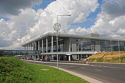
 The airport's terminal prior to the war in Donbas | |||||||||||
| Summary | |||||||||||
| Airport type | Public | ||||||||||
| Owner | |||||||||||
| Serves | |||||||||||
| Elevation AMSL | 238 m / 781 ft | ||||||||||
| Coordinates | 48°04′30″N 037°43′32″E / 48.07500°N 37.72556°E | ||||||||||
| Website | https://dok.aero/ | ||||||||||
| Map | |||||||||||
 | |||||||||||
| Runways | |||||||||||
| |||||||||||
| Statistics (2014) | |||||||||||
| |||||||||||
 | |||||||||||
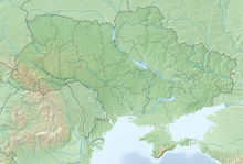
Donetsk Sergei Prokofiev International Airport[a] (IATA: DOK, ICAO: UKCC) is a former airport located 10 km (6.2 mi) northwest of Donetsk, Ukraine, that was destroyed in 2014 during the war in Donbas.[2][3] It was built in the 1940s, rebuilt in 1973, and then again from 2011 to 2012 for Euro 2012. In 2013, during its last full year of operation, it handled more than a million passengers.[4]
The airport is named after twentieth-century composer Sergei Prokofiev, who was a native of the region. The former airport, after being destroyed during the 1st and 2nd Battles of Donetsk Airport, has been controlled by pro-Russian separatist forces since 2015 and has occasionally since been a battleground.
- ^ EAD Basic
- ^ "Donetsk Airport Cyborgs". Ukraine Today. October 15, 2014. Retrieved October 15, 2014.
- ^ "Донецкий аэропорт потерял стратегическое значение, поэтому отпала необходимость его удерживать – Генштаб". Unian. January 29, 2015.
- ^ "The battle for Ukraine's Donetsk airport – in pictures". The Guardian. January 23, 2015. ISSN 0261-3077. Retrieved December 30, 2022.
Cite error: There are <ref group=lower-alpha> tags or {{efn}} templates on this page, but the references will not show without a {{reflist|group=lower-alpha}} template or {{notelist}} template (see the help page).


