| Dong Phaya Yen Mountains | |
|---|---|
 The Dong Phaya Yen Mountains rising east of Pa Sak Cholasit Dam | |
| Highest point | |
| Peak | Phu Khing |
| Elevation | 1,167 m (3,829 ft) |
| Dimensions | |
| Length | 170 km (110 mi) NW/SE |
| Width | 40 km (25 mi) NE/SW |
| Geography | |
| Country | Thailand |
| Provinces | |
| Range coordinates | 14°20′N 102°03′E / 14.33°N 102.05°E |
| Borders on | |
| Geology | |
| Rock type(s) | Sandstone and limestone[1] |
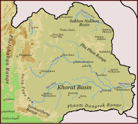
Dong Phaya Yen or Dong Phya Yen[2] (Thai: ทิวเขาดงพญาเย็น, pronounced [dōŋ pʰājāː jēn], lit. "jungle of the cold lord") is a mountain range in Phetchabun, Chaiyaphum, Lopburi, Saraburi, and Nakhon Ratchasima Provinces, Thailand.
As the Dong Phaya Yen is less compact and lower in height than the mountain ranges to the north and to the south, the first roads and railroads connecting the region of Isan with the capital Bangkok were built across these mountains. Before the construction of the railroad at the beginning of the 20th century, communication between these two parts of Thailand was difficult. The survey for the building of the Northeastern Line of the State Railway of Thailand began in 1887.
- ^ "The Caves of Lopburi - Caves & Caving in Thailand" (PDF). Archived from the original (PDF) on 2019-01-19. Retrieved 2013-03-27.
- ^ Land Use in Northeastern Thailand
