Dover Plains, New York | |
|---|---|
 East view along Mill Street | |
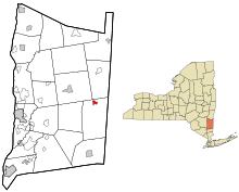
 Location of Dover Plains, New York | |
| Coordinates: 41°44′27″N 73°34′35″W / 41.74083°N 73.57639°W | |
| Country | United States |
| State | New York |
| County | Dutchess |
| Town | Dover |
| Area | |
| • Total | 0.70 sq mi (1.82 km2) |
| • Land | 0.68 sq mi (1.77 km2) |
| • Water | 0.02 sq mi (0.05 km2) |
| Elevation | 400 ft (100 m) |
| Population (2020) | |
| • Total | 1,322 |
| • Density | 1,932.75/sq mi (746.32/km2) |
| Time zone | UTC-5 (Eastern (EST)) |
| • Summer (DST) | UTC-4 (EDT) |
| ZIP code | 12522 |
| Area code | 845 |
| FIPS code | 36-20841 |
| GNIS feature ID | 0948613 |
Dover Plains is a hamlet and census-designated place (CDP) in Dutchess County, New York, United States. The population was 1,322 at the 2020 census.[2][3] It is part of the Poughkeepsie–Newburgh–Middletown Metropolitan Statistical Area.
Dover Plains is in the northern part of the town of Dover on NY Route 22.
Metro-North Railroad has a Harlem Line station here, bringing commuters to New York City. This station was the line's northern terminus until 1852 when the line was carried farther north to Chatham.
- ^ "ArcGIS REST Services Directory". United States Census Bureau. Retrieved September 20, 2022.
- ^ "Geographic Identifiers: 2010 Demographic Profile Data (G001): Dover Plains CDP, New York". U.S. Census Bureau, American Factfinder. Archived from the original on February 13, 2020. Retrieved November 18, 2015.
- ^ United States Census Bureau, 2020 Results, Dover Plains, New York https://www.census.gov/search-results.html?searchType=web&cssp=SERP&q=Dover%20Plains%20CDP,%20New%20York