This article needs additional citations for verification. (November 2023) |
Downtown Kansas City | |
|---|---|
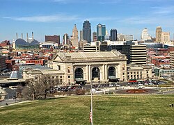
 The downtown Kansas City skyline | |
 | |
| Coordinates: 39°06′00″N 94°35′04″W / 39.09997°N 94.58431°W | |
| Country | United States |
| State | Missouri |
| Counties | Jackson County |
| City | Kansas City |
| Area | |
• Total | 6.23 sq mi (16.14 km2) |
| • Land | 6.23 sq mi (16.14 km2) |
| • Water | 0 sq mi (0 km2) 0% |
| Elevation | 800 ft (200 m) |
| Population (2020) | |
• Total | 28,000 |
| • Density | 4,495/sq mi (1,400/km2) |
| ZIP code | 64101, 64102, 64105, 64106, 64108, and 64109 |
| Area code | 816 |
| Website | https://downtownkc.org |
Downtown Kansas City is the central business district (CBD) of Kansas City, Missouri and the Kansas City metropolitan area which contains 3.8% of the area's employment.[1] It is between the Missouri River in the north, to 31st Street in the south; and from the Kansas–Missouri state line eastward to Bruce R. Watkins Drive as defined by the Downtown Council of Kansas City;[2] the 2010 Greater Downtown Area Plan formulated by the City of Kansas City defines the Greater Downtown Area to be the city limits of North Kansas City and Missouri to the north, the Kansas–Missouri state line to the west, 31st Street to the south and Woodland Avenue to the east.[3] However, the definition used by the Downtown Council is the most commonly accepted.
In March 2012, Downtown Kansas City was selected as one of America's Best downtowns by Forbes magazine for its rich culture in arts, numerous fountains, upscale shopping, and local cuisine such as barbecue.[4]
- ^ http://www.demographia.com/db-cbd2000.pdf
- ^ "General Information". Downtown Council of Kansas City. Downtown Council of Kansas City. Archived from the original on 20 September 2015. Retrieved 2 September 2013.
- ^ "Greater Downtown Area Plan" (PDF). City of Kansas City, Missouri. City of Kansas City, Missouri. Retrieved 2 September 2013.[permanent dead link]
- ^ Giuffo, John. "America's Best Downtowns". Forbes.