| Drin | |
|---|---|
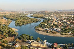
 Drin delta flowing through Shkodër | |
 | |
| Location | |
| Countries | |
| Region | Southern Europe |
| Cities | |
| Physical characteristics | |
| Source | White Drin at Zhleb Mountains near Radavc |
| • location | Kosovo, Peja District |
| 2nd source | Black Drin at Lake Ohrid near Struga |
| • location | North Macedonia, Struga Municipality |
| Source confluence | Near Kukës |
| • location | Kukës County, Albania |
| Mouth | Large Drin: Buna Small Drin: Gulf of Drin |
• location | Large Drin: Shkodër County Small Drin: Lezhë County, Albania |
• elevation | 5 m (16 ft) |
| Length | 285 km (177 mi)[1][A] |
| Basin size | 19,686 km2 (7,601 sq mi)[4] |
| Discharge | |
| • location | the river mouth |
| • average | 352 m3/s (12,400 cu ft/s)[2] |
| • maximum | 1,800[3] m3/s (64,000 cu ft/s) |
| Basin features | |
| Progression | Adriatic Sea |
| Tributaries | |
| • left | Black Drin, Mirusha, Prizren, Toplluha |
| • right | White Drin, Sateska, Radika, Perro, Bushtrica, White Drin: Peja, Deçan, Erenik, Black Drin: Valbona, Shala, Kir, Mertur |
The Drin (/driːn/;[5] Albanian: Drin [dɾin] or Drini [ˈdɾini]; Macedonian: Дрим, romanized: Drim [drim]) is a river in Southeastern Europe with two major tributaries – the White Drin and the Black Drin and two distributaries – one discharging into the Adriatic Sea, in the Gulf of Drin and the other into the Bojana River. Its catchment area extends across Albania, Kosovo, Serbia, Greece, Montenegro and North Macedonia[6][7] and is home to more than 1.6 million people.[8] The river and its tributaries form the Gulf of Drin, an ocean basin that encompasses the northern Albanian Adriatic Sea Coast.
At 285 kilometres (177 miles) long,[1][9][10] the Drin is the longest river of Albania and its tributaries cross through both Kosovo and North Macedonia. Its northern tributary, the White Drin starts from the foothills of Žljeb, at White Drin Waterfall in west Kosovo, and flows generally south, whereas its southern tributary, the Black Drin originates from Ohrid lake in the town of Struga, North Macedonia and flows north. Both tributaries' confluence occurs near Kukës in northeast Albania and Drin then flows westwards through the Albanian Alps and Dukagjin Highlands, where three successive dams were erected between 1960s and late 1980s, forming 3 large artificial lakes. The Drin then passes Vau i Dejës and drains into the Adriatic Sea through its two distributaries in Buna river and west of Lezhë.
Located in the Balkan Peninsula at the crossroad of Europe and Asia, the river basin's varied climate and topography have shaped a vast array of flora and fauna. In addition, it has been recognized as one of the most important biodiversity hotspots in Europe.[11][12] The Drin Delta is classified as an Important Bird Area of international importance by designation under the BirdLife International Convention.[13]
- ^ a b Pešić, Vladimir; Milošević, Djuradj; Miliša, Marko (2021). Small Water Bodies of the Western Balkans. Switzerland: Springer Nature. p. 368. ISBN 9783030864781.
It is simultaneously the longest river in the country, with a length of 285 km.
- ^ Kabo, Mevlan (1990). Gjeografia Fizike e Shqipërisë 1 (in Albanian). Tirana, Albania: Akademia e Shkencave e RPS të Shqipërisë. p. 232.
Prurja mesatare shumëvjeçare e Drinit të Zi është 118 m3/sek, e Drinit të Bardhë 68.8 m3/sek, e Drinit (në derdhje në Bunë) 352 m3/sek që i përgjigjet një vëllimi vjetor prej 11.1 miliardë m3 ujë.
- ^ Food and Agriculture Organization of the United Nations. "ALBANIA". fao.org.
- ^ Elisabeta Poci. "HYDROLOGY OF THE TRANSBOUNDARY DRIN RIVER BASIN" (PDF). ce.utexas.edu. University of Texas at Austin.
- ^ "Drin". dictionary.com.
- ^ "Internationally Shared Surface Water Bodies in the Balkan Region". inweb.gr.
- ^ Cite error: The named reference
Streissguth2011was invoked but never defined (see the help page). - ^ "Drin Basin". Drin Corda.
- ^ Elsie, Robert (2010). Historical Dictionary of Albania. Scarecrow Press. p. 118. ISBN 9780810861886.
- ^ Kabo, Mevlan (1990). Gjeografia Fizike e Shqipërisë 1 (in Albanian). Tirana, Albania: Akademia e Shkencave e RPS të Shqipërisë. pp. 231–232.
- ^ "The natural wealth and legacy of the Drin River Basin: inspiring our collective actions" (PDF). act4drin.net. p. 7.
- ^ "Drin River Basin The blue heart of the Balkans" (PDF). mio-ecsde.org. p. 4.
- ^ BirdLife International. "Drini Delta". datazone.birdlife.org.