Drumright, Oklahoma | |
|---|---|
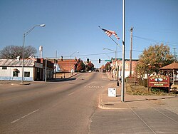
 Downtown Drumright (2010) | |
| Motto: "Oklahoma's Boomtown" | |
 Location within Creek County and Oklahoma | |
| Coordinates: 35°59′26″N 96°35′52″W / 35.99056°N 96.59778°W | |
| Country | United States |
| State | Oklahoma |
| Counties | Creek, Payne |
| Area | |
| • Total | 7.39 sq mi (19.15 km2) |
| • Land | 7.39 sq mi (19.14 km2) |
| • Water | 0.00 sq mi (0.01 km2) |
| Elevation | 791 ft (241 m) |
| Population (2020) | |
| • Total | 2,560 |
| • Density | 346.46/sq mi (133.77/km2) |
| Time zone | UTC-6 (Central (CST)) |
| • Summer (DST) | UTC-5 (CDT) |
| ZIP code | 74030 |
| Area code(s) | 539/918 |
| FIPS code | 40-21750 [3] |
| GNIS feature ID | 2410360[2] |
| Website | cityofdrumright.com |
Drumright is a city in Creek and Payne counties in the U.S. state of Oklahoma. It began as an oil boom town. However, the population has declined as oil production has waned in the area. The population was 2,907 at the 2010 census, a figure almost unchanged from 2,905 in 2000.[4] Drumright and nearby Cushing were at the center of the large, productive Cushing-Drumright Oil Field in the 1910s and 1920s. Now Drumright is home to a festival called The Drumright Monthly Market, where hundreds of visitors come on the first Saturday of every month, seeking crafts and delicacies from all over the region. Drumright is also home to The yearly OilPatch Parade and Jamboree Jog, Annual Cruising the Hills car show, Joseph's Restaurant, and Babe Ruth played on our very own baseball field. We have a sign dedicated to Babe Ruth at the entry to the sports complex area. You can find out more from Jamey Martin at Joseph's and the Museum.
- ^ "ArcGIS REST Services Directory". United States Census Bureau. Retrieved September 20, 2022.
- ^ a b U.S. Geological Survey Geographic Names Information System: Drumright, Oklahoma
- ^ "U.S. Census website". United States Census Bureau. Retrieved January 31, 2008.
- ^ "CensusViewer: Population of the City of Drumright, Oklahoma". Archived from the original on June 15, 2013. Retrieved March 22, 2012.