Duhamel-Ouest | |
|---|---|
 Fort Temiscamingue | |
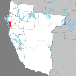
 Location within Témiscamingue RCM | |
| Coordinates: 47°22′N 79°26′W / 47.367°N 79.433°W[1] | |
| Country | Canada |
| Province | Quebec |
| Region | Abitibi-Témiscamingue |
| RCM | Témiscamingue |
| Settled | 1870s |
| Constituted | February 20, 1911 |
| Government | |
| • Mayor | Alain Sarrazin |
| • Federal riding | Abitibi—Témiscamingue |
| • Prov. riding | Rouyn-Noranda–Témiscamingue |
| Area | |
| • Total | 128.81 km2 (49.73 sq mi) |
| • Land | 91.49 km2 (35.32 sq mi) |
| Population (2021)[3] | |
| • Total | 945 |
| • Density | 10.3/km2 (27/sq mi) |
| • Pop (2016–21) | |
| • Dwellings | 470 |
| Time zone | UTC−5 (EST) |
| • Summer (DST) | UTC−4 (EDT) |
| Postal code(s) | |
| Area code | 819 |
| Website | municipalites-du-quebec |
Duhamel-Ouest is a municipality in northwestern Quebec, Canada in the Témiscamingue Regional County Municipality.
Located at a narrows of Lake Timiskaming, Duhamel-Ouest is home to the Fort Témiscamingue, a National Historic Site of Canada.
- ^ Cite error: The named reference
toponymiewas invoked but never defined (see the help page). - ^ a b "Répertoire des municipalités: Geographic code 85030". www.mamh.gouv.qc.ca (in French). Ministère des Affaires municipales et de l'Habitation. Retrieved 2023-12-01.
- ^ a b "Duhamel-Ouest census profile - 2021 Census data". www12.statcan.gc.ca. Government of Canada - Statistics Canada. Retrieved 2022-04-14.
