| Dulcie Range National Park Northern Territory | |
|---|---|
 Dulcie Range National Park N.T. | |
| Nearest town or city | Alice Springs |
| Coordinates | 22°32′14″S 135°32′37″E / 22.5372°S 135.5436°E[2] |
| Established | 1 March 1991[1] |
| Area | 191.12 km2 (73.8 sq mi)[1] |
| Managing authorities | Parks and Wildlife Commission of the Northern Territory |
| See also | Protected areas of the Northern Territory |
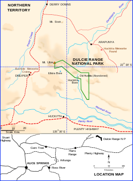
Dulcie Range is a national park in the Northern Territory of Australia, 220 km north-east of Alice Springs and 1235 km southeast of territorial capital of Darwin.[2][3] The park lies along the south-western edge of Dulcie Range. It was first declared in 1991 and again in July 2012.[4] A draft Plan of Management was published by the Parks and Wildlife Commission of the Northern Territory in May 2001.
- ^ a b c "CAPAD 2012 Northern Territory Summary (see 'DETAIL' tab)". CAPAD 2012. Australian Government - Department of the Environment. 7 February 2014. Retrieved 7 February 2014.
- ^ a b "Place Names Register Extract for "Dulcie Range National Park"". NT Place Names Register. Northern Territory Government. Retrieved 4 February 2020.
- ^ Hema, Maps (2005). Australia's Great Desert Tracks NE Sheet (Map). Eight Mile Plains Queensland: Hema Maps. ISBN 978-1865005461.
- ^ Hampton, Karl Rio (20 July 2012). "Territory Parks and Wildlife Conservation Act, REDECLARATION OF PARK" (PDF). Northern Territory Government Gazette. Northern Territory Government. Archived from the original (PDF) on 4 February 2020. Retrieved 4 February 2020.
