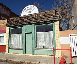
Duncan, Arizona | |
|---|---|
Town | |
 Bank of Duncan – 1908 | |
 Location of Duncan in Greenlee County, Arizona | |
| Coordinates: 32°44′00″N 109°05′52″W / 32.73333°N 109.09778°W | |
| Country | United States |
| State | Arizona |
| County | Greenlee |
| Incorporated | 1938[citation needed] |
| Government | |
| • Type | Municipal (Council/Manager Form) |
| Area | |
| • Total | 2.15 sq mi (5.57 km2) |
| • Land | 2.15 sq mi (5.57 km2) |
| • Water | 0.00 sq mi (0.00 km2) |
| Elevation | 3,763 ft (1,147 m) |
| Population (2020) | |
| • Total | 694 |
| • Density | 322.49/sq mi (124.52/km2) |
| Time zone | UTC−7 (MST (no DST)) |
| ZIP code | 85534 |
| Area code | 928 |
| FIPS code | 04-20750 |
| GNIS feature ID | 2412451[2] |
| Website | duncanaz |
Duncan is a town in Greenlee County, Arizona, United States. As of the 2010 census, the population of the town was 696.[3] In 2018 the estimated population was 789.[4]
Duncan is in the Gila River valley, four miles (6 km) west of the Arizona–New Mexico border. The town limits are on both sides of the Gila River, but the primary portion of the town and the entire downtown area lies on the south side of the river.
Duncan was founded in the mid-19th century, and the land was added to the United States as a part of the Mexican Cession, and the Gadsden Purchase. The town of Duncan has been destroyed twice by flood and once by fire.[when?]
The town and unincorporated county surrounding the town are primarily populated by farming, ranching, and mining families. (Freeport-McMoRan Inc., Morenci & Safford copper mines in southeastern Arizona and Chino & Tyrone in southwestern New Mexico). Surrounding smaller unincorporated settlements such as Franklin and York in Arizona, and the Village of Virden, New Mexico, all use Duncan public schools. The areas along the Gila River are renowned for Native American artifacts such as arrowheads, pottery, burial sites, cave paintings, and other remnants of the Anasazi and other pre-historic cultures that inhabited the area until overpopulation and severe droughts between 1000 and 1290 C.E. caused them to vanish, (a remnant of the Chiricahua Band of Apache Indians remained in the upper Gila River Valley as late as the 1930s) as well as artifacts from garrison camps of the expedition of Francisco Vázquez de Coronado.
Duncan High School (mascot: Wildkat; school colors: red, grey, and white) competes in many sports, Fall- Mens "8 Man" Football AIA Div 1, Ladies VolleyBall, M/W Cross-country; Winter - M/W Basketball; Spring - Mens Baseball, Womens Softball, M/W Tennis, M/W Golf, M/W Track & Field.
U.S. Supreme Court Justice Sandra Day O'Connor was born in El Paso, Texas, but grew up near Duncan on the Lazy B ranch, which straddles the border between Arizona and New Mexico. The Day family ran the ranch for many years until selling it; it continues to be run as a ranch. O'Connor later wrote a book titled Lazy B: Growing up on a Cattle Ranch in the American Southwest about her childhood experiences on the ranch with her brother H. Alan Day.
- ^ "2020 U.S. Gazetteer Files". United States Census Bureau. Retrieved October 29, 2021.
- ^ a b U.S. Geological Survey Geographic Names Information System: Duncan, Arizona
- ^ "Geographic Identifiers: 2010 Demographic Profile Data (G001): Duncan town, Arizona". U.S. Census Bureau, American Factfinder. Retrieved November 9, 2016.[dead link]
- ^ "Population and Housing Unit Estimates". Retrieved June 4, 2019.

