Dunlap, Ohio | |
|---|---|
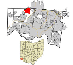
 Location in Hamilton County and the state of Ohio. | |
| Coordinates: 39°17′26″N 84°37′35″W / 39.29056°N 84.62639°W | |
| Country | United States |
| State | Ohio |
| County | Hamilton |
| Area | |
| • Total | 6.66 sq mi (17.26 km2) |
| • Land | 6.53 sq mi (16.91 km2) |
| • Water | 0.13 sq mi (0.34 km2) |
| Elevation | 653 ft (199 m) |
| Population (2020) | |
| • Total | 1,658 |
| • Density | 253.87/sq mi (98.02/km2) |
| Time zone | UTC−5 (Eastern (EST)) |
| • Summer (DST) | UTC−4 (EDT) |
| FIPS code | 39-22960[3] |
| GNIS feature ID | 2585508[2] |
Dunlap is a census-designated place (CDP) in Colerain Township, Hamilton County, Ohio, United States. The population was 1,658 at the 2020 census. The siege of Dunlap's Station was a battle that took place near here on the Great Miami in 1791 during the Northwest Indian War.
- ^ "ArcGIS REST Services Directory". United States Census Bureau. Retrieved September 20, 2022.
- ^ a b U.S. Geological Survey Geographic Names Information System: Dunlap, Ohio
- ^ "U.S. Census website". United States Census Bureau. Retrieved January 31, 2008.