Dunnigan | |
|---|---|
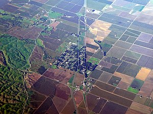
 Aerial view of Dunnigan in December 2021 | |
| Coordinates: 38°53′07″N 121°58′11″W / 38.88528°N 121.96972°W | |
| Country | |
| State | |
| County | Yolo County |
| Area | |
| • Total | 5.23 sq mi (13.55 km2) |
| • Land | 5.23 sq mi (13.55 km2) |
| • Water | 0.00 sq mi (0.00 km2) 0% |
| Elevation | 69 ft (21 m) |
| Population (2020) | |
| • Total | 1,382 |
| • Density | 264.14/sq mi (101.98/km2) |
| ZIP code[3] | 95937 |
| Area code | 530 |
| FIPS code | 06-20228 |
| GNIS feature IDs | 222740, 2583003 |
Dunnigan (formerly, Antelope) is a census-designated place in Yolo County, California on Interstate 5. The population was 1,416 at the 2010 census. Dunnigan's ZIP code is 95937 and its area code 530. It lies at an elevation of 69 feet (21 m).
- ^ "2020 U.S. Gazetteer Files". United States Census Bureau. Retrieved October 30, 2021.
- ^ "222740". Geographic Names Information System. United States Geological Survey, United States Department of the Interior.
- ^ "ZIP Code(tm) Lookup". United States Postal Service. Retrieved December 20, 2014.
