Dura | |
|---|---|
| Arabic transcription(s) | |
| • Arabic | دورا |
| • Latin | Durrah (official) |
 | |
Location of Dura within Palestine | |
| Coordinates: 31°30′25″N 35°01′40″E / 31.50694°N 35.02778°E | |
| Palestine grid | 152/101 |
| State | |
| Governorate | Hebron |
| Government | |
| • Type | City (from 1967) |
| • Head of Municipality | Mr. Ahmad Salhoub |
| Population (2017)[1] | |
| • Total | 39,336 |
| Name meaning | Dura (proper noun) from Hebrew אֲדוֹרַים Adoraim[2] |
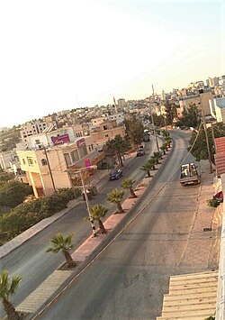
Dura (Arabic: دورا) is a Palestinian city located eleven kilometers southwest of Hebron, in the southern West Bank, in the Hebron Governorate of the State of Palestine. According to the Palestinian Central Bureau of Statistics, the town had a population of 39,336 in 2017.[1] The current mayor is Ahmad Salhoub.
In 1517, Dura was incorporated into the Ottoman Empire with the rest of Syria. In the late Ottoman and early Mandatory periods, Dura was the only permanent settlement in the southeastern ridge of the central highlands. Starting as a village and evolving into a town, it sprawled across large territories, becoming a center for influential families, collectively referred to as Abu-Darham.[3]
After the British Mandate, in the wake of the 1948 Arab–Israeli War, Dura came under Jordanian rule. Dura was established as a municipality on January 1, 1967, five months before it came under Israeli occupation after the Six-Day War. Since 1995, it has been governed by the Palestinian National Authority, as part of Area A of the West Bank and as part of the Hebron Governorate of the State of Palestine.
- ^ a b Preliminary Results of the Population, Housing and Establishments Census, 2017 (PDF). Palestinian Central Bureau of Statistics (PCBS) (Report). State of Palestine. February 2018. pp. 64–82. Retrieved 2023-10-24.
- ^ Palmer, 1881, p. 393
- ^ Grossman, D. (1994). Expansion and Desertion: the Arab Village and its Offshoots in Ottoman Palestine (in Hebrew). Jerusalem: Yad Izhak Ben-Zvi. pp. 220–221.

