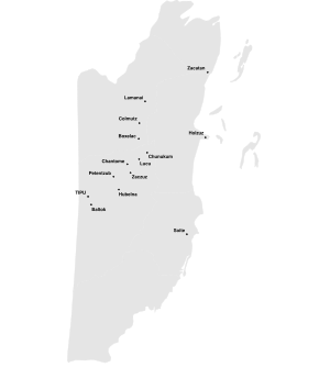
Province of Dzuluinicob u kuchkabal Ts'ulwinikob (Yucatec Maya) | |||||||||||||||
|---|---|---|---|---|---|---|---|---|---|---|---|---|---|---|---|
| 11th cent.–1544 | |||||||||||||||
 Capital and provincial settlements of Dzuluinicob towards the 16th cent. / in present-day Belize / some locations uncertain / 2022 map following map 2 in Jones 1989 / via Commons[c] | |||||||||||||||
| Status | Dissolved | ||||||||||||||
| Capital | Tipu[a] | ||||||||||||||
| Common languages | Yucatec Maya[b] | ||||||||||||||
| Religion | Maya polytheism | ||||||||||||||
| Government | Confederation of towns with aristocratic features | ||||||||||||||
| Historical era | Postclassic to Spanish conquest | ||||||||||||||
| 10th cent. | |||||||||||||||
• Established | 11th cent. | ||||||||||||||
| 13th cent. | |||||||||||||||
| 1461 | |||||||||||||||
| 1544 | |||||||||||||||
| |||||||||||||||
| Today part of | Belize | ||||||||||||||
a.^ Per Jones 1989, p. 98, Graham 2011, p. 55. b.^ Per Jones 1989, p. 98, Morris et al. 2010, pp. 90–91. c.^ See sec. 'Legacy' subsec. 'Scholarly' in this article for debate regarding inclusion or exclusion of various provincial settlements (eg Lamanai). | |||||||||||||||
Dzuluinicob, or the Province of Dzuluinicob or Ts'ulwinikob, (/zjuːl.ˈwiː.nɪ.kɔːb/ zool-WEE-nih-cawb; Yucatec Maya: u kuchkabal Ts'ulwinikob; Mayan pronunciation: [u kutʃ.ka.ˈbal t͡sʼul.ˌwiː.niː.ˈkoɓ]) was a Postclassic Maya state in the Yucatán Peninsula of the Maya Lowlands.[note 1]
Cite error: There are <ref group=note> tags on this page, but the references will not show without a {{reflist|group=note}} template (see the help page).
