| Eagle Cap Wilderness | |
|---|---|
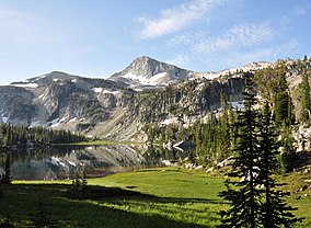
 Mirror Lake in the Eagle Cap Wilderness | |
| Location | Wallowa / Union / Baker counties, Oregon, United States |
| Nearest city | Enterprise, Oregon |
| Coordinates | 45°14′32″N 117°26′30″W / 45.24222°N 117.44167°W |
| Area | 361,446 acres (146,272 ha) |
| Established | 1940 |
| Governing body | U.S. Forest Service |

Eagle Cap Wilderness is a wilderness area located in the Wallowa Mountains of northeastern Oregon (United States), within the Wallowa–Whitman National Forest.[1] The wilderness was established in 1940. In 1964, it was included in the National Wilderness Preservation System. A boundary revision in 1972 added 73,000 acres (30,000 ha) and the Wilderness Act of 1964 added 66,100 acres (26,700 ha) resulting in its current size of 361,446 acres (146,272 ha; 565 sq mi), making Eagle Cap by far Oregon's largest wilderness area.[2]
Eagle Cap Wilderness is named after a peak in the Wallowa Mountains, which were once called the Eagle Mountains. At 9,572 feet (2,918 m) Eagle Cap was incorrectly thought to be the highest peak in the range.[3]
- ^ Wallowa–Whitman National Forest - Eagle Cap Wilderness
- ^ Eagle Cap Wilderness, Oregon Archived 2010-05-13 at the Wayback Machine - GORP
- ^ McArthur, Lewis A.; Lewis L. McArthur (2003) [1928]. Oregon Geographic Names (Seventh ed.). Portland, Oregon: Oregon Historical Society Press. ISBN 0-87595-277-1. (trade paperback), (hardcover).
