Tom Clarke Bridge Droichead Thomáis Uí Chléirigh | |
|---|---|
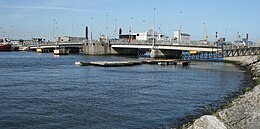
 The bridge from the south bank of the Liffey looking downstream | |
| Coordinates | 53°20′45″N 6°13′39″W / 53.3457°N 6.2274°W |
| Crosses | River Liffey |
| Locale | Dublin |
| Maintained by | Dublin City Council |
| Preceded by | Samuel Beckett Bridge |
| Characteristics | |
| Design | Bascule bridge |
| History | |
| Construction cost | £8 million |
| Opened | 21 October 1984 |
| Statistics | |
| Daily traffic | 14,000-17,000 |
| Toll |
|
| Location | |
 | |
The Tom Clarke Bridge (Irish: Droichead Thomáis Uí Chléirigh), formerly and commonly known as the East-Link Toll Bridge, is a toll bridge in Dublin, Ireland, on the River Liffey, owned and operated by Dublin City Council. The bascule-type lifting bridge, which links North Wall to Ringsend, is the last bridge on the Liffey, which opens out into Dublin Port and then Dublin Bay just beyond. The bridge forms part of the R131 regional road.