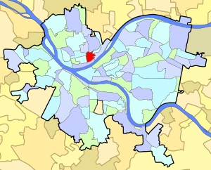
East Allegheny | |
|---|---|
 | |
| Coordinates: 40°27′22″N 80°00′00″W / 40.456°N 80.000°W | |
| Country | United States |
| State | Pennsylvania |
| County | Allegheny County |
| City | Pittsburgh |
| Area | |
| • Total | 0.236 sq mi (0.61 km2) |
| Population (2010)[1] | |
| • Total | 2,136 |
| • Density | 9,100/sq mi (3,500/km2) |
| ZIP Code | 15212 |
Deutschtown Historic District | |
| Area | Roughly bounded by Cedar Avenue, Knoll, East, and Pressley Streets |
| Architectural style | Late Victorian |
| NRHP reference No. | 83004181[2] |
| Significant dates | |
| Added to NRHP | November 25, 1983 |
| Designated CPHD | February 12, 1997[3] |
East Allegheny, also known as Deutschtown, is a neighborhood on Pittsburgh's North Side. It has a ZIP code of 15212, and has representation on Pittsburgh City Council by the council member for District 1 (North Central Neighborhoods). The Pittsburgh Bureau of Fire houses 32 engines and 32 trucks in Deutschtown.
- ^ a b "PGHSNAP 2010 Raw Census Data by Neighborhood". Pittsburgh Department of City Planning. 2012. Retrieved June 24, 2013.
- ^ "NPS Focus". National Register of Historic Places. National Park Service. Archived from the original on July 25, 2008. Retrieved August 5, 2011.
- ^ "Local Historic Designations". Pittsburgh, PA: Pittsburgh History & Landmarks Foundation. Retrieved August 5, 2011.


