East Auckland | |
|---|---|
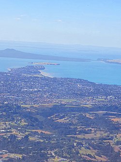
 An aerial view of some of the suburbs traditionally considered East Auckland, including Bucklands Beach, Howick and Botany Downs. | |
Location in the Auckland Region | |
| Coordinates: 36°55′S 174°55′E / 36.91°S 174.91°E | |
| Country | New Zealand |
| Island | North Island |
| Region | Auckland Region |
| NZ Parliament | Botany Pakuranga |
| Government | |
| • MPs | Simeon Brown (National) Christopher Luxon (National) |
| Area | |
| • Total | 69.68 km2 (26.90 sq mi) |
| Population (2023 estimation) | |
| • Total | 157,700 |
| • Density | 2,300/km2 (5,900/sq mi) |
East Auckland (Māori: Te Rāwhiti o Tāmaki Makaurau) is one of the major geographical regions of Auckland, the largest city in New Zealand. Settled in the 14th century, the area is part of the traditional lands of Ngāi Tai ki Tāmaki. The area was developed into farmland in the 1840s, and the town of Howick was established as a defensive outpost by fencibles (retired British Army soldiers) to protect Auckland. Coastal holiday communities developed in the area from the 1910s, and from the 1950s underwent major redevelopment into a suburban area of greater Auckland. From the 1980s, the area saw significant Asian New Zealander migrant communities develop.
