| East Branch Delaware River | |
|---|---|
 East Branch at Margaretville, New York | |
 | |
| Location | |
| Country | United States |
| State | New York |
| Region | Catskills |
| County | Delaware |
| Towns | Roxbury, Middletown, Andes, Colchester, Hancock |
| Physical characteristics | |
| Source | Unnamed pond |
| • location | SW of Grand Gorge |
| • coordinates | 42°21′21″N 74°31′03″W / 42.35583°N 74.51750°W[1] |
| • elevation | 1,560 ft (480 m) |
| Mouth | Delaware River |
• location | Hancock |
• coordinates | 41°56′20″N 75°16′45″W / 41.93889°N 75.27917°W[1] |
• elevation | 883[1] ft (269 m) |
| Length | 75[1] mi (121 km) |
| Basin size | 828 sq mi (2,140 km2) |
| Discharge | |
| • average | 1,715 cu ft/s (48.6 m3/s) |
| • maximum | 77,400 cu ft/s (2,190 m3/s) |
| Basin features | |
| River system | Delaware River |
| Tributaries | |
| • left | Beaver Kill, Dry Brook |
| • right | Platte Kill |
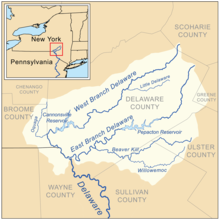
The East Branch Delaware River is one of two branches that form the Delaware River. It is approximately 75 mi (121 km) long, and flows through the U.S. state of New York. It winds through a mountainous area on the southwestern edge of Catskill Park in the Catskill Mountains for most of its course, before joining the West Branch along the northeast border of Pennsylvania with New York. Much of it is paralleled by State Route 30.
The river was impounded just north of Downsville in the mid-20th century to create Pepacton Reservoir, part of the New York City water supply system supplying drinking water to the City. It is a popular destination for fly fishing for brown trout.
In 1881 John Burroughs, a native of the area, published "A Summer Voyage", recounting a solo boat trip down the East Branch from Arkville to Hancock.[2]
There are many variant names for the river that include: Papaconck, Papakonk River, Papotunk River, Pepachton River, Pepacton Branch, Popacton River, Popaxtunk Branch.[1]
- ^ a b c d e "East Branch Delaware River". Geographic Names Information System. United States Geological Survey, United States Department of the Interior. Retrieved 2017-12-05.
- ^ "Pepacton: A Summer Voyage". Writings of John Burroughs. oldandsold.com. Retrieved 31 January 2015.