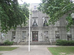
East Carroll Parish | |
|---|---|
 East Carroll Parish Courthouse in Lake Providence | |
 Location within the U.S. state of Louisiana | |
 Louisiana's location within the U.S. | |
| Coordinates: 32°44′N 91°14′W / 32.73°N 91.24°W | |
| Country | |
| State | |
| Founded | March 26, 1877 |
| Named for | Charles Carroll of Carrollton |
| Seat | Lake Providence |
| Largest town | Lake Providence |
| Area | |
• Total | 442 sq mi (1,140 km2) |
| • Land | 421 sq mi (1,090 km2) |
| • Water | 22 sq mi (60 km2) 4.9% |
| Population (2020) | |
• Total | 7,459 |
| • Density | 17/sq mi (6.5/km2) |
| Time zone | UTC−6 (Central) |
| • Summer (DST) | UTC−5 (CDT) |
| Congressional district | 5th |
East Carroll Parish (French: Paroisse de Carroll Est) is a parish located in the Mississippi Delta in northeastern Louisiana. As of 2020, its population was 7,459.[1] The parish seat is Lake Providence.[2] An area of cotton plantations in the antebellum era, the parish in the early 21st century has about 74% of its land devoted to agriculture.
- ^ "Explore Census Data". data.census.gov. Retrieved December 19, 2021.
- ^ "Find a County". National Association of Counties. Archived from the original on July 12, 2012. Retrieved June 7, 2011.