East Gojjam
ምሥራቅ ጎጃም Misraq Gojjam | |
|---|---|
 | |
| Country | |
| Region | |
| Capital | Debre Markos |
| Area | |
• Total | 14,004.47 km2 (5,407.16 sq mi) |
| Population (2017 est.) | |
• Total | 2,351,855 |
| • Density | 170/km2 (430/sq mi) |

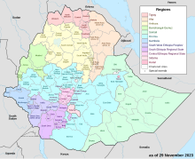
East Gojjam (Amharic: ምሥራቅ ጎጃም), also called Misraq Gojjam, is a zone in Amhara Region of Ethiopia. Its capital is Debre Markos. East Gojjam is named after the former province of Gojjam.
East Gojjam is bordered on the south by the Oromia Region, on the west by West Gojjam, on the north by South Gondar, and on the east by South Wollo; the bend of the Abay River defines the Zone's northern, eastern and southern boundaries. Its highest point is Mount Choqa (also known as Mount Birhan). Towns and cities in East Gojjam include Bichena, Debre Marqos, Debre Werq, and Mota.
This Zone was selected by the Ministry of Agriculture and Rural Development in 2004 as one of the several areas for voluntary resettlement for farmers from overpopulated areas; no specific woredas in this Zone were identified in this program. East Gojjam became the new home for a total of 20,000 heads of households and 80,000 total family members.[2]
- ^ Geohive: Ethiopia Archived 2012-08-05 at the Wayback Machine
- ^ "Resettlement 2004" Archived February 27, 2008, at the Wayback Machine, Disaster Prevention and Preparedness Agency (DPPA) (accessed 26 November 2006)