East India
Eastern India | |
|---|---|
 | |
| Coordinates: 23°15′N 86°00′E / 23.25°N 86.00°E | |
| Country | India |
| States and territories | |
| Largest city | Kolkata |
| Most populous cities (2011) | Bihar:
Jharkhand:
Odisha:
|
| Area | |
| • Total | 418,323 km2 (161,515 sq mi) |
| Population | |
| • Total | 226,925,195 |
| • Density | 540/km2 (1,400/sq mi) |
| Time zone | IST (UTC+5:30) |
| Official languages | |
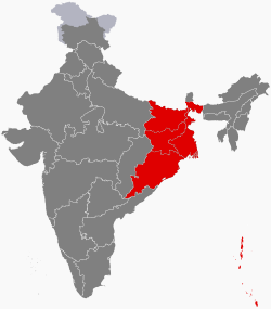
Eastern India is a region of India consisting of the Indian states of Bihar,[1] Jharkhand,[2] Odisha[3] and West Bengal[4] and also the union territory of the Andaman and Nicobar Islands.[5]
The states of Bihar and West Bengal lie on the Indo-Gangetic plain. Jharkhand is situated on the Chota Nagpur Plateau. Odisha lies on the Eastern Ghats and the Deccan Plateau. West Bengal's capital Kolkata is the largest city of this region. The Kolkata Metropolitan Area is the country's third largest metropolitan region. The region is bounded by Bhutan, Nepal and the state of Sikkim in the north, the states of Uttar Pradesh and Chhattisgarh on the west, the state of Andhra Pradesh in the south and the country of Bangladesh in the east. It is also bounded by the Bay of Bengal in the south-east. It is connected to the Seven Sister States of Northeast India by the narrow Siliguri Corridor in the north east of West Bengal. East India has the fourth-largest gross domestic product of all Indian regions.
The region was ruled by several empires, including Gangaridai, Nandas, Mauryans, Guptas, Palas, Senas, Eastern Gangas, Gajapatis, Delhi Sultanate, Bengal Sultanate, Mughal Empire and the British Empire.
- ^ "State Profile". Bihar Government website.
- ^ Govt. of Jharkhand. "Official Site of Government of Jharkhand, India". Archived from the original on 22 April 2016. Retrieved 25 April 2016.
- ^ "Odisha Tourism". odishatourism.gov.in. Archived from the original on 23 December 2016. Retrieved 23 December 2016.
- ^ Govt of West Bengal. "Official Site of Government of West Bengal, India". Westbengal.gov.in. Archived from the original on 4 March 2000. Retrieved 15 June 2013.
- ^ "Eastern Region – Geological Survey of India". Geological Survey of India, MOI, Government of India. Archived from the original on 24 September 2015. Retrieved 2 May 2015.