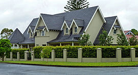
| East Killara Sydney, New South Wales | |||||||||||||||
|---|---|---|---|---|---|---|---|---|---|---|---|---|---|---|---|
 House, 100 Springdale Road | |||||||||||||||
 | |||||||||||||||
| Population | 2,895 (2021 census)[1] | ||||||||||||||
| • Density | 905/km2 (2,340/sq mi) | ||||||||||||||
| Postcode(s) | 2071 | ||||||||||||||
| Elevation | 125 m (410 ft) | ||||||||||||||
| Area | 3.2 km2 (1.2 sq mi) | ||||||||||||||
| Location | 15 km (9 mi) NW of Sydney CBD | ||||||||||||||
| LGA(s) | Ku-ring-gai Council | ||||||||||||||
| State electorate(s) | Davidson | ||||||||||||||
| Federal division(s) | Bradfield | ||||||||||||||
| |||||||||||||||
East Killara is a suburb on the Upper North Shore of Sydney in the state of New South Wales, Australia. East Killara is located 15 kilometres north of the Sydney Central Business District in the local government area of Ku-ring-gai Council. It is bordered by Garigal national park to the East and Eastern Arterial Rd/ Birdwood Ave to the west. Killara is a separate suburb to the south-west, which shares the postcode of 2071.
East Killara is set in peaceful bushland. The main road is Koola Avenue which extends from Birdwood Avenue to Albany Crescent.
- ^ Australian Bureau of Statistics (28 June 2022). "East Killara". 2021 Census QuickStats. Retrieved 30 January 2024.