| East Lindfield Sydney, New South Wales | |||||||||||||||
|---|---|---|---|---|---|---|---|---|---|---|---|---|---|---|---|
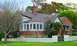
 c. 1930 house, Sydney Road | |||||||||||||||
 | |||||||||||||||
| Population | 3,710 (2021 census)[1] | ||||||||||||||
| Postcode(s) | 2070 | ||||||||||||||
| Elevation | 103 m (338 ft) | ||||||||||||||
| Location | 13 km (8 mi) NW of Sydney CBD | ||||||||||||||
| LGA(s) | Ku-ring-gai Council | ||||||||||||||
| State electorate(s) | Davidson | ||||||||||||||
| Federal division(s) | Bradfield | ||||||||||||||
| |||||||||||||||
East Lindfield is a suburb on the Upper North Shore of Sydney in the state of New South Wales, Australia. East Lindfield is located 13 kilometres north-west of the Sydney Central Business District in the local government area of Ku-ring-gai Council. Lindfield is a separate suburb to the west sharing the postcode of 2070.
- ^ Australian Bureau of Statistics (28 June 2022). "East Lindfield (State Suburb)". 2021 Census QuickStats. Retrieved 13 August 2024.