East St. Louis, Illinois | |
|---|---|
 East St. Louis and the Gateway Geyser | |
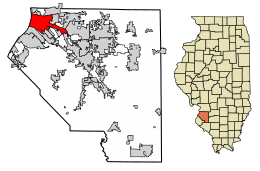
 Location of East St. Louis in St. Clair County, Illinois | |
| Coordinates: 38°37′30″N 90°09′27″W / 38.62500°N 90.15750°W | |
| Country | |
| State | |
| County | St. Clair |
| Township | East St. Louis (coterminous) |
| Founded | June 6, 1820 |
| Incorporated | February 16, 1865[1] |
| Government | |
| • Type | Council–manager |
| • Mayor | Charles Powell III |
| Area | |
| • Total | 14.30 sq mi (37.03 km2) |
| • Land | 13.92 sq mi (36.05 km2) |
| • Water | 0.38 sq mi (0.98 km2) |
| Elevation | 423 ft (129 m) |
| Population (2020) | |
| • Total | 18,469 |
| • Estimate (2023)[4] | 17,642 |
| • Density | 1,326.89/sq mi (512.33/km2) |
| Time zone | UTC−6 (CST) |
| • Summer (DST) | UTC−5 (CDT) |
| ZIP Codes | 62201–62207[5] |
| Area code | 618 |
| FIPS code | 17-163-22268 |
| GNIS feature ID | 2394607[3] |
| Website | cesl.us |
East St. Louis is a city in St. Clair County, Illinois, United States. It is directly across the Mississippi River from downtown St. Louis, Missouri, and the Gateway Arch National Park. East St. Louis is in the Metro East region of Southern Illinois. Once a bustling industrial center, like many cities in the Rust Belt, East St. Louis was severely affected by the loss of jobs due to the flight of the population to the suburbs during the riots of the late 1960s. In 1950, East St. Louis was the fourth-largest city in Illinois when its population peaked at 82,366. As of the 2020 census, the city had a population of 18,469,[6] less than one-quarter of the 1950 census and a decline of almost one third since 2010.
A recent addition to the city's waterfront is the Gateway Geyser. On the grounds of Malcolm W. Martin Memorial Park, the fountain is the second-tallest in the world. Designed to complement the Gateway Arch across the river in St. Louis, it shoots water to a height of 630 feet (190 m), the same height as the arch.
- ^ "Archived copy" (PDF). Archived from the original (PDF) on March 13, 2016. Retrieved May 25, 2016.
{{cite web}}: CS1 maint: archived copy as title (link) - ^ "2020 U.S. Gazetteer Files". United States Census Bureau. Retrieved March 15, 2022.
- ^ a b U.S. Geological Survey Geographic Names Information System: East St. Louis, Illinois
- ^ "Annual Estimates of the Resident Population for Counties: April 1, 2020 to July 1, 2023". United States Census Bureau. Retrieved March 24, 2024.
- ^ "East St. Louis ZIP Codes". zipdatamaps.com. 2022. Retrieved November 9, 2022.
- ^ "East St. Louis city, Illinois". United States Census Bureau. Retrieved April 15, 2022.

