Eastabuchie, Mississippi | |
|---|---|
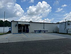
 Eastabuchie Post Office | |
| Coordinates: 31°26′08″N 89°17′00″W / 31.43556°N 89.28333°W | |
| Country | United States |
| State | Mississippi |
| County | Jones |
| Area | |
| • Total | 1.90 sq mi (4.91 km2) |
| • Land | 1.89 sq mi (4.89 km2) |
| • Water | 0.01 sq mi (0.02 km2) |
| Elevation | 171 ft (52 m) |
| Population (2020) | |
| • Total | 187 |
| • Density | 99.10/sq mi (38.26/km2) |
| Time zone | UTC-6 (Central (CST)) |
| • Summer (DST) | UTC-5 (CDT) |
| Area code | 601 |
| FIPS code | 28-20740 |
| GNIS feature ID | 669617 |
Eastabuchie is a census-designated place and unincorporated community in southwestern Jones County, Mississippi.[2] It is located along U.S. Route 11, just north of the Forrest County line. the community has a post office with the ZIP code 39436.[3] Eastabuchie is part of the Laurel Micropolitan Statistical Area.
- ^ "2020 U.S. Gazetteer Files". United States Census Bureau. Retrieved July 24, 2022.
- ^ U.S. Geological Survey Geographic Names Information System: Eastabuchie, Mississippi
- ^ USPS – Cities by ZIP Code

