| Eastern South Asia | |
|---|---|
 | |
| Countries | |
| Population | 441 million |
| Languages | Assamese, Bengali, Bodo, Bhojpuri, Chittagonian, Dzongkha, Hindi, Kamtapuri, Maithili, Magahi, Meitei, Nepali, Odia, Sadri, Sylheti |
| Time Zones | UTC+5:30, UTC+5:45, UTC+06:00 |
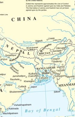
Eastern South Asia[1][2][3] is a subregion of South Asia. It includes the countries of Bangladesh, Bhutan, India (specifically East India and Northeast India), and Nepal. Geographically, it lies between the Eastern Himalayas and the Bay of Bengal. Two of the world's largest rivers, the Ganges and the Brahmaputra, flow into the sea through Eastern South Asia. The region includes the world's highest mountainous terrain and the world's largest delta, and has a climate ranging from alpine and subalpine to subtropical and tropical. Since Nepal, Bhutan, and northeast India are landlocked, the coastlines of Bangladesh and East India serve as the principal gateways to the region.
With more than 441 million inhabitants, Eastern South Asia is home to 6% of the world's population and 25% of South Asia's population. The Bangladesh, Bhutan, India, Nepal Initiative promotes economic integration in the region. The four countries are members of the South Asian Association for Regional Cooperation and the Bay of Bengal Initiative for Multi-Sectoral Technical and Economic Cooperation. Yunnan Province and the Tibet Autonomous Region of the People's Republic of China (PRC) and Myanmar are historically, economically, and culturally interdependent on Eastern South Asia. The Bangladesh–China–India–Myanmar Forum has established an economic corridor in the region.
- ^ "Sub-Regional Relations in the Eastern South Asia: With Special Focus on India's North Eastern Region - Joint Research Program Series No.133 - Institute of Developing Economies". Ide.go.jp. Archived from the original on 2017-08-14. Retrieved 2017-07-18.
- ^ Ambassador Rajiv Bhatia; Mr Swaran Singh; Ms Reena Marwah (15 November 2013). Transforming South Asia: Imperatives for Action: Imperatives for Action. KW Publishers Pvt Ltd. pp. 61–. ISBN 978-93-85714-61-0.
- ^ Sadiq Ahmed; Saman Kelegama; Ejaz Ghani (2 February 2010). Promoting Economic Cooperation in South Asia: Beyond SAFTA. SAGE Publications. p. 140. ISBN 978-81-321-0497-1.