Easterville | |
|---|---|
Unincorporated community | |
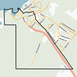
 Community boundaries | |
| Coordinates: 53°06′27″N 99°48′46″W / 53.10750°N 99.81278°W | |
| Country | Canada |
| Province | Manitoba |
| Established | 1962 |
| Government | |
| • Type | Mayor–council |
| • Chief | Clarence Easter |
| • Councillors |
|
| Area | |
| • Land | 3.31 km2 (1.28 sq mi) |
| Population (2016) | |
| • Total | 44 |
| • Density | 13.3/km2 (34/sq mi) |
| • Summer (DST) | UTC-4 |
Easterville is an unincorporated community, designated as a northern community, in the Canadian province of Manitoba.[1]
It is situated 200 kilometres southeast of The Pas and 100 kilometres (40 km by air) west of Grand Rapids, on the south shore of Cedar Lake. Its elevation above sea level is 265 metres (869 ft). The Chemawawin Cree Nation community is adjacent to the community on Cedar Lake.
The current community of Easterville was established in 1962, when nearby native populations were being displaced by the building of the Grand Rapids Dam, which flooded their prior ~80-year-old community of Chemawawin.[2]
- ^ Government of Canada, Statistics Canada (2017-02-08). "Population and Dwelling Count Highlight Tables, 2016 Census". www12.statcan.gc.ca. Retrieved 2021-08-13.
- ^ (31 July 2010). Paradise Lost, Winnipeg Free Press
