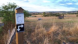
Ebsdorfergrund | |
|---|---|
 Direction sign regarding a hiking trail in Ebsdorfergrund, Hesse, Germany | |
Location of Ebsdorfergrund within Marburg-Biedenkopf district  | |
| Coordinates: 50°44′N 08°52′E / 50.733°N 8.867°E | |
| Country | Germany |
| State | Hesse |
| Admin. region | Gießen |
| District | Marburg-Biedenkopf |
| Government | |
| • Mayor (2022–28) | Hanno Kern[1] |
| Area | |
| • Total | 72.89 km2 (28.14 sq mi) |
| Elevation | 219 m (719 ft) |
| Population (2022-12-31)[2] | |
| • Total | 9,033 |
| • Density | 120/km2 (320/sq mi) |
| Time zone | UTC+01:00 (CET) |
| • Summer (DST) | UTC+02:00 (CEST) |
| Postal codes | 35085 |
| Dialling codes | 06424 |
| Vehicle registration | MR |
| Website | www.ebsdorfergrund.de |
Ebsdorfergrund is a municipality consisting of eleven villages in the southeast of Marburg-Biedenkopf district in Hesse, Germany.
The community's municipal area extends over the Ebsdorfer Grund in the valley of the Zwester Ohm and the areas around its edges, connecting the Amöneburg Basin with the middle Lahn valley between Marburg and Gießen.
Through the municipal area runs a highway from Fronhausen (Autobahn interchange in Gießen by Bundesstraße B 3) to Kirchhain. Another one joins Marburg with Grünberg.
The old ring railway, the Marburger Kreisbahn, which opened in 1905 and ran through the municipal area to Dreihausen, was shut down in 1972.
- ^ "Ergebnisse der jeweils letzten Direktwahl von Landrätinnen und Landräte sowie (Ober-)Bürgermeisterinnen und (Ober-)Bürgermeister in Hessen, Stand 13.04.2023" (in German). Hessisches Statistisches Landesamt. Archived from the original (XLS) on 2023-07-07. Retrieved 2023-07-06.
- ^ "Bevölkerung in Hessen am 31.12.2022 nach Gemeinden" (XLS) (in German). Hessisches Statistisches Landesamt. June 2023.


