| Egrisi Range | |
|---|---|
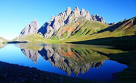
 Egrisi Range with Tobavarchkhili Lake in the foreground | |
| Highest point | |
| Elevation | 3,226 m (10,584 ft) |
| Dimensions | |
| Length | 62 km (39 mi) |
| Width | 37 km (23 mi) |
| Geography | |
| Country | |
| Range coordinates | 42°42′30″N 42°36′42″E / 42.70833°N 42.61167°E |
| Parent range | Caucasus Mountains |
Egrisi Range (Georgian: ეგრისის ქედი), also known as the Samegrelo Range (სამეგრელოს ქედი) or the Odishi Range (ოდიშის ქედი), is an east–west mountain range that runs parallel to the Greater Caucasus Mountain Range in the Samegrelo-Zemo Svaneti region of Georgia. The Range is connected to the Greater Caucasus Mountain Range via the Svaneti Range. The length of the Egrisi Range is 62 kilometres (39 miles) and the width is 37 kilometres (23 miles). The Range is bounded by the Tskhenistsqali River Valley to the east and the Enguri River Valley to the west.[1][2]
The highest point of the Egrisi Range is Mount Chitagvala which rises to an elevation of 3,226 meters (10,584 feet) above sea level.[3] Peaks that exceed 3,000 meters (9,800 feet) in elevation include Tsalmagi, Tekhurishdudi, Lakumurashdudi, Didghalidudi, Otepura and others. The name of the range is derived from the early medieval Georgian region of Egrisi, roughly equivalent to the Colchis of Classical Antiquity.
- ^ Tielidze, Levan, ed. (2018). Geomorphology of Georgia. Springer. pp. 130–132. ISBN 9783319777641.
- ^ Maruashvili, L. (1979). "ეგრისის ქედი [Egrisi Range]". ქართული საბჭოთა ენციკლოპედია, ტ. 4 [Georgian Encyclopaedia, Vol. 4] (in Georgian). Tbilisi. p. 26.
{{cite book}}: CS1 maint: location missing publisher (link) - ^ "ჭითაგვალა" [Chitagvala]. Mountains in Georgia (in Georgian). Retrieved 14 November 2021.

