| Eider Canal | |
|---|---|
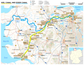
 Map of the Eider Canal (blue) and succeeding Kiel Canal in Schleswig-Holstein | |
 | |
| Specifications | |
| Length | 107 miles (172 km) (Man-made segment ran for 26 miles (42 km)[1]) |
| Locks | 6 |
| Maximum height above sea level | 23 ft (7.0 m) |
| Status | Replaced by Kiel Canal |
| History | |
| Date of act | 14 April 1774 |
| Construction began | 1776 |
| Date completed | 1784 |
| Date closed | 1887 |
| Geography | |
| Start point | Tönning (North Sea) |
| End point | Kiel (Baltic Sea) |
The Eider Canal (also called the Schleswig-Holstein Canal) was an artificial waterway in southern Denmark (later northern Germany) which connected the North Sea with the Baltic Sea by way of the rivers Eider and Levensau. Constructed between 1777 and 1784, the Eider Canal was built to create a path for ships entering and exiting the Baltic that was shorter and less storm-prone than navigating around the Jutland peninsula. In the 1880s the canal was replaced by the enlarged Kiel Canal, which includes some of the Eider Canal's watercourse.[2]
- ^ Vernon-Harcourt, Leveson Francis (1896). Rivers and Canals (2nd ed.). Oxford: Clarendon Press. p. 571.
- ^ "Eider River". Encyclopædia Britannica. Retrieved 19 October 2016.