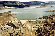
| El Vado Dam | |
|---|---|
 | |
| Country | United States |
| Location | Rio Arriba County, New Mexico |
| Coordinates | 36°35′41″N 106°43′58″W / 36.59472°N 106.73278°W |
| Owner(s) | U.S. Bureau of Reclamation |
| Dam and spillways | |
| Type of dam | Earthfill |
| Impounds | Rio Chama |
| Height | 229.5 ft (70.0 m) |
| Length | 1,326 ft (404 m) |
| Dam volume | 608,000 cu yd (465,000 m3) |
| Spillways | 2x |
| Spillway type | Concrete overflow, service |
| Spillway capacity | 17,800 cu ft/s (500 m3/s) |
| Reservoir | |
| Creates | El Vado Lake |
| Total capacity | 196,500 acre⋅ft (242,400,000 m3) |
| Catchment area | 492 sq mi (1,270 km2) |
| Surface area | 3,200 acres (1,300 ha) |
| Maximum water depth | 167.1 ft (50.9 m) |
| Power Station | |
| Installed capacity | 8 MW |
El Vado Dam impounds the Rio Chama in the U.S. state of New Mexico, about 105 miles (169 km) north-northwest of New Mexico's largest city, Albuquerque and about 80 miles (130 km) northwest of the capital city of Santa Fe. The earth-filled structure forms El Vado Lake, a storage reservoir for the Middle Rio Grande Project, and has been designated as a New Mexico Historic Civil Engineering Landmark by the American Society of Civil Engineers.[1][2]
