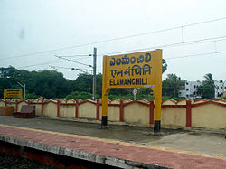
Elamanchili | |
|---|---|
Town | |
 Elamanchili Railway Station | |
| Coordinates: 17°33′6″N 82°51′15″E / 17.55167°N 82.85417°E | |
| Country | |
| State | Andhra Pradesh |
| District | Anakapalli |
| Government | |
| • Type | Municipality |
| • Body | Elamanchili Municipality, Visakhapatnam Metropolitan Region Development Authority |
| • MLA | Uppalapati Venkata Ramanamurthy Raju |
| Area | |
| • Total | 39.00 km2 (15.06 sq mi) |
| Elevation | 7 m (23 ft) |
| Population | |
| • Total | 27,265 |
| • Density | 700/km2 (1,800/sq mi) |
| Languages | |
| • Official | Telugu |
| Time zone | UTC+5:30 (IST) |
| PIN | 531055 |
| Telephone code | 08931 |
| Vehicle Registration | AP31 (Former) AP39 (from 30 January 2019)[3] |
Elamanchili is a town in Anakapalli district of the Indian state of Andhra Pradesh. It is a municipality and also the mandal headquarters of Elamanchili mandal. The town is spread over an area of 39 km2 (15 sq mi), which is under the jurisdiction of Visakhapatnam Metropolitan Region Development Authority.[4] This town has historical importance dating back to 7th Century AD.

- ^ "Municipalities, Municipal Corporations & UDAs" (PDF). Directorate of Town and Country Planning. Government of Andhra Pradesh. Archived from the original (PDF) on 28 January 2016. Retrieved 29 January 2016.
- ^ "Census 2011". The Registrar General & Census Commissioner, India. Retrieved 26 July 2014.
- ^ "New 'AP 39' code to register vehicles in Andhra Pradesh launched". The New Indian Express. Vijayawada. 31 January 2019. Archived from the original on 3 February 2019. Retrieved 9 June 2019.
- ^ "Mandal wise list of villages in Visakhapatnam district" (PDF). Chief Commissioner of Land Administration. National Informatics Centre. Archived from the original (PDF) on 19 March 2015. Retrieved 6 March 2016.
