Eldon | |
|---|---|
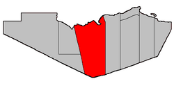
 Location within Restigouche County. | |
| Coordinates: 47°45′00″N 67°04′30″W / 47.75°N 67.075°W | |
| Country | |
| Province | |
| County | Restigouche |
| Erected | 1827 |
| Dissolved | 1879 |
| Reërected | 1896 |
| Area | |
| • Land | 1,688.58 km2 (651.96 sq mi) |
| Population (2021)[1] | |
• Total | 674 |
| • Density | 0.4/km2 (1/sq mi) |
| • Change 2016-2021 | |
| • Dwellings | 369 |
| Time zone | UTC-4 (AST) |
| • Summer (DST) | UTC-3 (ADT) |
| Population change reflects revised total for 2016.[1] | |
Eldon is a geographic parish in Restigouche County, New Brunswick, Canada.[4]
For governance purposes it is divided between the incorporated rural community of Kedgwick[5] and the Restigouche rural district,[6] both of which are members of the Restigouche Regional Service Commission.[7]
Before the 2023 governance reform, the parish was divided into four local service districts and part of another. Mann Mountain was opposite the mouth of the Matapedia River, with Flatlands straddling the eastern border; St. Jean Baptiste – Menneval, White's Brook were both along Route 17, nearer Kedgwick than Campbellton; the LSD of the parish of Eldon comprised the remainder of the parish.[8] In the reform, Kedgwick annexed the community of Wyers Brook, properties on either side of Route 17 south from Glenwood, and all of the parish to the west;[5] the remainder became part of the rural district.[6]
- ^ a b c "Census Profile". Statistics Canada. 26 October 2022. Retrieved 29 October 2022.
- ^ "Chapter T-3 Territorial Division Act". Government of New Brunswick. Retrieved 24 January 2023.
- ^ "Chapter I-13 Interpretation Act". Government of New Brunswick. Retrieved 24 January 2023.
- ^ The Territorial Division Act[2] divides the province into 152 parishes, the cities of Saint John and Fredericton, and one town of Grand Falls. The Interpretation Act[3] clarifies that parishes include any local government within their borders.
- ^ a b "Restigouche Regional Service Commission: RSC 2". Government of New Brunswick. Retrieved 24 January 2023.
- ^ a b "Restigouche Regional Service Commission: RD 2". Government of New Brunswick. Retrieved 24 January 2023.
- ^ "Regions Regulation – Regional Service Delivery Act". Government of New Brunswick. 21 July 2022. Retrieved 24 January 2023.
- ^ "Local Service Districts Regulation - Municipalities Act". Government of New Brunswick. 25 June 2021. Retrieved 24 January 2023.