| Creswick Victoria—Legislative Assembly | |
|---|---|
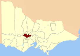
 Location in Victoria | |
| State | Victoria |
| Created | 1859 |
| Abolished | 1904 |
| Demographic | Rural |
Creswick was an electoral district of the Legislative Assembly in the colony, and later Australian state of Victoria centred on the town of Creswick from 1859 to 1904.[1]
As defined in the 1858 Electoral Act, its area was bound by Greens Gully, Loddon River, the Great Dividing Range, the Coliban River, Middleton Creek, and Limestone Creek.[2]
- ^ "Re-Member (Former Members)". State Government of Victoria. Retrieved 24 April 2013.
- ^ "An Act to alter the Electoral Districts of Victoria and to increase the number of Members of the Legislative Assembly thereof" (PDF). 1858. Retrieved 24 July 2013.