| North Melbourne Victoria—Legislative Assembly | |
|---|---|
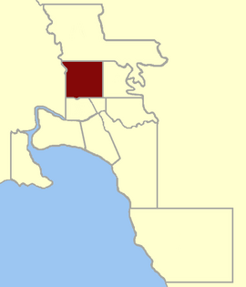
 Location within Greater Melbourne area, 1859 | |
| State | Victoria |
| Created | 1859 |
| Abolished | 1927 |
| Demographic | Metropolitan |
North Melbourne was an electoral district of the Legislative Assembly[1] in the Australian state of Victoria from 1859[2] to 1927.
The Electoral District of North Melbourne was defined as being bound by Victoria Street/Parade on the south, Nicholson Street on the east, the southern boundary of portion 90, parish of Jika Jika on the north and a line south from Mains Bridge (now Flemington Bridge)[3] to the Victoria Street alignment by the 1858 Electoral Districts Act.[2] This included the suburbs of Carlton, Parkville and North Melbourne.
The district was abolished, along with several others, when the Electoral Districts Act 1926[4] was implemented in 1927.
- ^ "Re-Member (Former Members)". State Government of Victoria. Retrieved 2 May 2013.
- ^ a b "An Act to alter the Electoral Districts of Victoria and to increase the number of Members of the Legislative Assembly thereof" (PDF). Australasian Legal Information Institute. 1858. Retrieved 2 May 2013.
- ^ "Moonee Valley Thematic Environmental History, p.50". Retrieved 2 May 2013.
- ^ "Electoral Districts Act 1926". Australasian Legal Information Institute. Retrieved 14 June 2013.