| Elliot Formation | |
|---|---|
| Stratigraphic range: Norian-Pliensbachian ~ | |
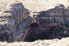
 Elliot Formation caves in the Matalane Valley, Leribe, Lesotho | |
| Type | Geological formation |
| Unit of | Stormberg Group |
| Sub-units | Upper Elliot, Lower Elliot |
| Underlies | Clarens Formation |
| Overlies | Molteno Formation |
| Thickness | up to 500 m (1,600 ft) |
| Lithology | |
| Primary | Mudstone, sandstone |
| Other | Siltstone, conglomerate |
| Location | |
| Coordinates | 30°30′S 27°24′E / 30.5°S 27.4°E |
| Approximate paleocoordinates | 44°06′S 1°54′W / 44.1°S 1.9°W |
| Region | Eastern Cape, Free State, Mafeteng, Maseru, Quthing, Qacha's Nek & Mohale's Hoek |
| Country | |
| Type section | |
| Named for | Elliot, Eastern Cape |
The Elliot Formation is a geological formation and forms part of the Stormberg Group, the uppermost geological group that comprises the greater Karoo Supergroup. Outcrops of the Elliot Formation have been found in the northern Eastern Cape, southern Free State, and in the eastern KwaZulu-Natal provinces of South Africa. Outcrops and exposures are also found in several localities in Lesotho such as Qacha's Neck, Hill Top, Quthing, and near the capital, Maseru. The Elliot Formation is further divided into the lower (LEF) and upper (UEF) Elliot formations to differentiate significant sedimentological differences between these layers. The LEF is dominantly Late Triassic (Norian-Hettangian) in age while the UEF is mainly Early Jurassic (Sinemurian-Pliensbachian) and is tentatively regarded to preserve a continental record of the Triassic-Jurassic boundary in southern Africa.[1] This geological formation is named after the town of Elliot in the Eastern Cape, and its stratotype locality is located on the Barkly Pass, 9 km north of the town.[2][3][4]
- ^ Bordy, Emese M.; Abrahams, Miengah; Sharman, Glenn R.; Viglietti, Pia A.; Benson, Roger B.J.; McPhee, Blair W.; Barrett, Paul M.; Sciscio, Lara; Condon, Daniel; Mundil, Roland; Rademan, Zandri (April 2020). "A chronostratigraphic framework for the upper Stormberg Group: Implications for the Triassic-Jurassic boundary in southern Africa". Earth-Science Reviews. 203: 103120. Bibcode:2020ESRv..20303120B. doi:10.1016/j.earscirev.2020.103120. ISSN 0012-8252. S2CID 213646670.
- ^ Bordy, Emese M.; John Hancox, P.; Rubidge, Bruce S. (2004-03-01). "Fluvial style variations in the Late Triassic–Early Jurassic Elliot formation, main Karoo Basin, South Africa". Journal of African Earth Sciences. 38 (4): 383–400. Bibcode:2004JAfES..38..383B. doi:10.1016/j.jafrearsci.2004.02.004. ISSN 1464-343X.
- ^ "A description of the sedimentology and palaeontology of the Late Triassic–Early Jurassic Elliot Formation in Lesotho". WIReDSpace Wits. 2004-09-01. ISSN 0078-8554.
- ^ Bordy, E.M.; Eriksson, P. (2015-09-01). "Lithostratigraphy of the Elliot Formation (Karoo Supergroup), South Africa". South African Journal of Geology. 118 (3): 311–316. Bibcode:2015SAJG..118..311B. doi:10.2113/gssajg.118.3.311. hdl:2263/55739. ISSN 1012-0750.
