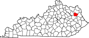
Elliott County | |
|---|---|
 Elliott County courthouse in Sandy Hook | |
 Location within the U.S. state of Kentucky | |
 Kentucky's location within the U.S. | |
| Coordinates: 38°07′00″N 83°06′00″W / 38.1167°N 83.1°W | |
| Country | |
| State | |
| Founded | 1869 |
| Named for | John Milton Elliott or John Lyle Elliot |
| Seat | Sandy Hook |
| Largest city | Sandy Hook |
| Area | |
| • Total | 235 sq mi (610 km2) |
| • Land | 234 sq mi (610 km2) |
| • Water | 1.0 sq mi (3 km2) 0.4% |
| Population (2020) | |
| • Total | 7,354 |
| • Estimate (2023) | 7,245 |
| • Density | 31/sq mi (12/km2) |
| Time zone | UTC−5 (Eastern) |
| • Summer (DST) | UTC−4 (EDT) |
| Congressional district | 5th |
| Website | elliottcounty |
Elliott County is a county located in the U.S. state of Kentucky. Its county seat is Sandy Hook.[1] The county was formed in 1869 from parts of Morgan, Lawrence, and Carter counties, and is named for John Milton Elliott a judge, U.S. Congressman, and a member of the 1st Confederate States Congress from Kentucky; he was also involved in the formation of the Confederate government of Kentucky.[2] Some historians, however, contend the county was named after John Milton Elliot's father, John Lyle Elliot a U.S. Congressman and Confederate Justice of the Kentucky Court of Appeals.[3][4] In regard to alcohol sales, Elliott County is a dry county, meaning the sale of alcoholic beverages is prohibited everywhere in the county.
- ^ "Find a County". National Association of Counties. Archived from the original on May 31, 2011. Retrieved June 7, 2011.
- ^ "Elliott County".
- ^ The Register of the Kentucky State Historical Society, Volume 1. Kentucky State Historical Society. 1903. p. 35.
- ^ Gannett, Henry (1905). The Origin of Certain Place Names in the United States. Govt. Print. Off. p. 117.