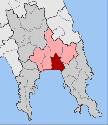
Elos
Έλος | |
|---|---|
| Coordinates: 36°50′N 22°42′E / 36.833°N 22.700°E | |
| Country | Greece |
| Administrative region | Peloponnese |
| Regional unit | Laconia |
| Municipality | Evrotas |
| Area | |
| • Municipal unit | 117.6 km2 (45.4 sq mi) |
| Elevation | 15 m (49 ft) |
| Population (2021)[1] | |
| • Municipal unit | 5,240 |
| • Municipal unit density | 45/km2 (120/sq mi) |
| • Community | 643 |
| Time zone | UTC+2 (EET) |
| • Summer (DST) | UTC+3 (EEST) |
| Postal code | 230 55 |
| Area code(s) | 27350 |
| Vehicle registration | ΑΚ |
Elos (Greek: Έλος, before 1930: Δουραλί - Dourali[2]) is a village and a former municipality in Laconia, Peloponnese, Greece. Since the 2011 local government reform it is part of the municipality Evrotas, of which it is a municipal unit.[3] The municipal unit has an area of 117.577 km2.[4] It had its own primary school until 2012. The seat of the municipality of Evrotas is in Skala. The inhabitants work as farmers producing oranges and olive oil. The municipal unit has a coastline on the Laconian Gulf. The river Evrotas is west of Elos. The name dates back to ancient times. It is located west of Monemvasia, east of Gytheio and southeast of Sparta.
- ^ "Αποτελέσματα Απογραφής Πληθυσμού - Κατοικιών 2021, Μόνιμος Πληθυσμός κατά οικισμό" [Results of the 2021 Population - Housing Census, Permanent population by settlement] (in Greek). Hellenic Statistical Authority. 29 March 2024.
- ^ Name changes of settlements in Greece
- ^ "ΦΕΚ B 1292/2010, Kallikratis reform municipalities" (in Greek). Government Gazette.
- ^ "Population & housing census 2001 (incl. area and average elevation)" (PDF) (in Greek). National Statistical Service of Greece. Archived from the original (PDF) on 2015-09-21.

