| Else | |
|---|---|
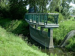
 The bifurcation near Melle: the Else is on the right and the Hase on the left. | |
 | |
| Location | |
| Country | Germany |
| States | North Rhine-Westphalia and Lower Saxony |
| Reference no. | DE: 466 |
| Physical characteristics | |
| Source | |
| • location | Origin: Bifurcation from the Hase near Melle |
| • coordinates | 52°12′16″N 8°15′22″E / 52.20444°N 8.25611°E |
| • elevation | ca. 79.9 m above sea level (NN) |
| Mouth | |
• location | Near Kirchlengern/Löhne into the Werre |
• coordinates | 52°11′56″N 8°40′42″E / 52.19889°N 8.67833°E |
• elevation | ca. 52 m above sea level (NN) |
| Length | 31.5 km (19.6 mi) [1] |
| Basin size | 415.5 km2 (160.4 sq mi) [1] |
| Basin features | |
| Progression | Werre→ Weser→ North Sea |
| Landmarks |
|
| Population | 100000 |
| Tributaries | |
| • left | Oldendorfer Mühlenbach, Zwickenbach, Eickener Mühlenbach, Suttbach, Kilverbach, Bennier Graben, Ahler Bruchgraben, Darmühlenbach, Gewinghauser Bach, Knollerbach, Ostbach (Mühlenbach), Eselsbach, Markbach, Sunderbach |
| • right | Strotbach, Laerbach, Maschgraben, Violenbach, Bruchriede, Mühlenbach, Alte Else, Warmenau, Neue Else with Werfener Bach, Brandbach (Bolldammbach) |
The Else is a left tributary of the river Werre in the northeast of North Rhine-Westphalia and in southern Lower Saxony. The Else is a distributary of the river Hase and begins at a river bifurcation near Melle.