This article needs additional citations for verification. (September 2019) |
Empangeni | |
|---|---|
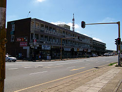
 Street in Empangeni | |
| Coordinates: 28°45′S 31°54′E / 28.750°S 31.900°E | |
| Country | South Africa |
| Province | KwaZulu-Natal |
| District | King Cetshwayo |
| Municipality | uMhlathuze |
| Area | |
| • Total | 154.47 km2 (59.64 sq mi) |
| Population (2022)[1] | |
| • Total | 110,340 |
| • Density | 710/km2 (1,900/sq mi) |
| Racial makeup (2022) | |
| • Black African | 61.3% |
| • Coloured | 2.8% |
| • Indian/Asian | 5.7% |
| • White | 31.9% |
| • Other | 0.2% |
| First languages (2022) | |
| • Zulu | 64.5% |
| • English | 22.9% |
| • Afrikaans | 18.6% |
| • S. Ndebele | 1.3% |
| • Other | 2.7% |
| Time zone | UTC+2 (SAST) |
| Postal code (street) | 3880 |
| PO box | 3880 |
| Area code | 035 |
Empangeni is a town in KwaZulu-Natal, South Africa. It is approximately 157 kilometres north of Durban, in hilly countryside, overlooking a flat coastal plain and the major harbour town of Richards Bay 16 kilometres away. The N2 freeway runs east from Empangeni intersecting John Ross Highway (R34) which connects Empangeni and Richards Bay.
The climate is sub-tropical with an average temperature of 28.4 °C in summer and 14.5 °C in Winter. The town is said, by local residents, to not have a real winter, as temperatures are seldom very low.
- ^ a b c d "Main Place Empangeni". Census 2011.

