Empire Township, Michigan | |
|---|---|
 Lake Michigan (left), Sleeping Bear Dunes, and South Bar Lake (right) from Empire Bluffs | |
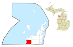
 Location within Leelanau County (red) and the administered village of Empire (pink) | |
| Coordinates: 44°50′02″N 86°00′49″W / 44.83389°N 86.01361°W | |
| Country | |
| State | |
| County | |
| Area | |
| • Total | 42.8 sq mi (110.9 km2) |
| • Land | 35.3 sq mi (91.3 km2) |
| • Water | 7.6 sq mi (19.6 km2) |
| Elevation | 961 ft (293 m) |
| Population (2020) | |
| • Total | 764 |
| • Density | 30.8/sq mi (11.9/km2) |
| Time zone | UTC-5 (Eastern (EST)) |
| • Summer (DST) | UTC-4 (EDT) |
| ZIP code(s) | |
| Area code | 231 |
| FIPS code | 26-26000[1] |
| GNIS feature ID | 1626241[2] |
| Website | www |
Empire Township is a civil township of Leelanau County in the U.S. state of Michigan. The population was 764 at the 2020 census. On the shores of Lake Michigan, Empire Township contains a substantial amount of land within the Sleeping Bear Dunes National Lakeshore.
- ^ "U.S. Census website". United States Census Bureau. Retrieved January 31, 2008.
- ^ U.S. Geological Survey Geographic Names Information System: Empire Township, Michigan

