| Entella | |
|---|---|
 Rainbow on the Entella near its mouth | |
 | |
| Location | |
| Country | Italy |
| Physical characteristics | |
| Source | |
| • location | Carasco |
| • elevation | 30 m (98 ft) |
| Mouth | Ligurian Sea |
• location | between Chiavari and Lavagna |
• coordinates | 44°18′35″N 9°19′54″E / 44.30972°N 9.33167°E |
• elevation | 0 m (0 ft) |
| Length | around 6 km (3.7 mi)[1] |
| Basin size | 376 km2 (145 sq mi)[2] |
| Discharge | |
| • average | 13.875 m3/s (490.0 cu ft/s)[3][4] |
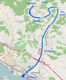
The Entella is a very short river within the Metropolitan City of Genoa (former Province of Genoa) in the Liguria region of northwestern Italy.
It and its tributaries flow from the Ligurian Apennines Mountains to the Ligurian Sea.
- ^ Giuseppe Valle (2015-03-14). "Chiavari: petizione per salvare il fiume Entella". Levante news. Retrieved May 11, 2015.
- ^ AA.VV. "CARATTERISTICHE ACQUE COSTIERE: scheda 19" (PDF). www.cartografiarl.regione.liguria.it. Regione Liguria. Archived from the original (PDF) on May 18, 2015. Retrieved May 11, 2015.
- ^ Cite error: The named reference
provgewas invoked but never defined (see the help page). - ^ 13.875 m3/s (490.0 cu ft/s) is an esteem of the real discharge; natural discharge (also considering artificial water derivations) = 14.53 m3/s (513 cu ft/s)