Enumclaw | |
|---|---|
| City of Enumclaw | |
 Aerial view of Enumclaw | |
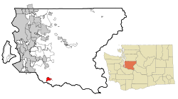
 Location of Enumclaw within King County, Washington | |
| Coordinates: 47°12′09″N 121°59′39″W / 47.20250°N 121.99417°W | |
| Country | United States |
| State | Washington |
| County | King |
| Platted | October 31, 1885 |
| Incorporated | January 27, 1913 |
| Government | |
| • Type | Mayor–council |
| • Mayor | Jan Molinaro |
| Area | |
| • Total | 5.17 sq mi (13.40 km2) |
| • Land | 5.17 sq mi (13.40 km2) |
| • Water | 0.00 sq mi (0.00 km2) |
| Elevation | 761 ft (232 m) |
| Population | |
| • Total | 12,543 |
| • Estimate (2022)[3] | 12,721 |
| • Density | 2,356.92/sq mi (910.02/km2) |
| Time zone | UTC-8 (Pacific (PST)) |
| • Summer (DST) | UTC-7 (PDT) |
| ZIP code | 98022 |
| Area code | 360 |
| FIPS code | 53-22045 |
| GNIS feature ID | 1519366[4] |
| Website | cityofenumclaw.net |

Enumclaw (/ˈiːnəmklɔː/ EE-nəm-klaw) is a city in King County, Washington, United States. The population was 12,543 at the 2020 census.[2]
The Enumclaw Plateau, on which the city resides, was formed by a volcanic mudflow (lahar) from Mount Rainier approximately 5,700 years ago.[5]
- ^ "2020 U.S. Gazetteer Files". United States Census Bureau. Retrieved July 24, 2022.
- ^ a b "Explore Census Data". United States Census Bureau. Retrieved August 29, 2023.
- ^ Cite error: The named reference
USCensusEst2022was invoked but never defined (see the help page). - ^ "Enumclaw". Geographic Names Information System. United States Geological Survey, United States Department of the Interior.
- ^ "About Buckley". Cityofbuckley.com. Archived from the original on September 27, 2011. Retrieved November 18, 2011.
